NORTHEASTERN NORTH CAROLINA – A winter storm will impact northeastern North Carolina this weekend, bringing snow showers, windy conditions, and dangerous cold. The National Weather Service in Wakefield, Virginia, issued a First Call Winter Storm Timeline on Wednesday, Jan. 28, 2026, outlining what residents can expect from Friday through Sunday night. Jan. 30-Feb. 1.
The storm system arrives as the region continues to deal with frigid Arctic air, with snow likely becoming more widespread Saturday and heavy snow possible along the coast Saturday night into Sunday.
According to the National Weather Service in Morehead City, snowfall rates may exceed 1 to 2 inches an hour during the peak of the snow. Blowing snow is likely, especially in open areas or near water. You can see their graphics at https://www.weather.gov/media/mhx/LatestBriefing.pdf
Day-by-Day Timeline
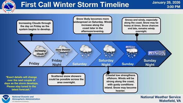
Friday, January 31: Increasing clouds throughout the day as the storm system begins to develop. Conditions will remain mostly dry, but snow showers could begin by Friday night as moisture increases.
Saturday, February 1: Snow likely becomes more widespread on Saturday, with winds increasing along the coast later in the afternoon and evening. This marks the main event of the storm system, with conditions deteriorating through the day.
Saturday Night into Sunday Morning: Snowy and windy conditions, especially along the coast. Snow may be heavy at times in coastal areas. Wind chill values will be dangerously low, and ice remains a possibility in some areas. This will be the most intense period of the storm.
Sunday, February 2: Coastal low-pressure system strengthens and moves northeast, keeping conditions windy and cold. Strong winds will persist along the coast, with blowing snow reducing visibility. Snow may linger in some inland areas during the day before conditions gradually improve Sunday night.
Key Concerns
Scattered Snow Showers Overnight Saturday: Scattered snow showers could be possible across the area overnight Saturday into Sunday, with heavier bands along the coast where the system will be most intense.
Strong Coastal Winds and Blowing Snow: As the coastal low strengthens Sunday, strong winds will create hazardous conditions along the coast, with blowing and drifting snow significantly reducing visibility. Travel could become extremely dangerous.
Windy Conditions Throughout: Expect windy conditions from Saturday through Sunday night across the entire region, not just along the coast. Combined with cold temperatures, wind chills will be dangerously low.
Forecast Uncertainty
The National Weather Service emphasizes that exact details will change over the next couple of days as the storm develops. Early indications are subject to revision, and residents are strongly encouraged to check back for the latest forecast updates.
Small shifts in the storm track can mean significant differences in snowfall amounts and which areas see the heaviest snow. The forecast will be refined as more data becomes available and the system takes shape.
This storm comes amid what forecasters are calling one of the longest cold spells in several decades. Arctic air has been locked in place across the eastern United States, and temperatures will remain well below normal throughout the weekend and into early next week.
Parts of northeastern North Carolina and Virginia are recovering from a major winter storm that struck January 24-26, bringing sleet, freezing rain, and snow. Lingering ice and snow from that event, combined with the persistent cold, means any additional winter precipitation this weekend could create compounding hazards.

Expected Impacts
- Travel: Roads will become snow-covered and hazardous, especially Saturday night through Sunday. Blowing snow will create whiteout conditions in some areas, making travel extremely dangerous or impossible. Avoid unnecessary travel during the height of the storm.
- Power Outages: Strong winds combined with heavy, wet snow could cause tree limbs to break and bring down power lines. Outages are possible, and the prolonged cold means any outages will be particularly dangerous.
- Marine: Gale-force winds and dangerous seas will make marine conditions extremely hazardous. All mariners should remain in port or seek safe harbor before conditions deteriorate Saturday.
- Cold: Dangerously low wind chills will create life-threatening conditions for anyone exposed to the elements. Frostbite can occur in minutes. Hypothermia is a serious risk, especially if power outages occur.
Stay Informed
The National Weather Service will issue winter weather watches, warnings, and advisories as the storm approaches. Monitor forecasts closely, as conditions and timing may change.
For the latest forecast information:
- Visit weather.gov and enter your ZIP code
- Follow NWS Wakefield on social media at @NWSWakefieldVA
- Follow NWS Raleigh at @NWSRaleigh for additional coverage
- Listen to NOAA Weather Radio for continuous updates
- Monitor local news outlets for road conditions and closures
This is a First Call forecast issued Wednesday, January 28, 2026 at 3 PM. Check back frequently for updates as the forecast becomes more certain. Source: National Weather Service, Wakefield, Virginia and NWS in Newport/Morehead City, NC