NOAA Fisheries recently established a new voluntary slow zone in waters east of Ocracoke Island, urging mariners to reduce their speed to help protect critically endangered North Atlantic right whales detected in the area.
Current Slow Zone Details
The East of Ocracoke, NC Dynamic Management Area (DMA) Slow Zone is in effect from November 18 through December 2, 2025. The protected area covers approximately 2,500 square miles of ocean bounded by:
- Northern Boundary: 35°16′ N
- Southern Boundary: 34°35′ N
- Eastern Boundary: 76°31′ W
- Western Boundary: 75°41′ W
All mariners transiting through this area are strongly encouraged to reduce their speed to 10 knots or less to minimize the risk of striking these endangered whales.

Why This Matters
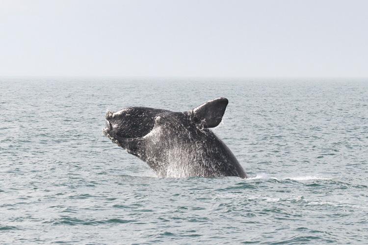
North Atlantic right whales are one of the world’s most endangered large whale species, with only about 360 individuals remaining and fewer than 70 reproductively active females. Since 2017, the species has been experiencing an Unusual Mortality Event, and vessel strikes have been identified as one of the two primary threats to their survival, along with entanglement in fishing gear.
These whales are particularly vulnerable to ship strikes because they spend much of their time at or near the water surface. Their dark coloring and lack of a dorsal fin make them extremely difficult to spot from vessels, especially in poor weather conditions, rough seas, or low light. Even experienced mariners can easily miss seeing a right whale until it’s too late to avoid a collision.
How Slow Zones Work
Dynamic Management Areas like the current zone east of Ocracoke are established when NOAA Fisheries detects three or more right whales in a specific area through visual sightings by aerial survey teams or acoustic monitoring. Unlike permanent Seasonal Management Areas that remain in effect for months at a time, DMAs are temporary and targeted, typically lasting 15 days from the date whales are detected.
While the slow zone is voluntary and not legally required for most vessels, NOAA strongly encourages all boaters — regardless of vessel size — to comply. Research has shown that reducing speed to 10 knots or less significantly decreases both the likelihood of striking a whale and the severity of injuries if a collision does occur. At higher speeds, whales have less time to move out of a vessel’s path, and the impact force increases dramatically.
The Broader Context
This slow zone is part of NOAA’s strategy to reduce vessel strikes along the Atlantic coast. Federal regulations already require vessels 65 feet or longer to travel at 10 knots or less in designated Seasonal Management Areas during certain times of the year. The Mid-Atlantic region, including waters off North Carolina, has mandatory speed restrictions in specific zones from November 1 through April 30.
The voluntary slow zones complement these mandatory restrictions by providing real-time, location-specific protection when whales are actually present. They allow NOAA to respond quickly to whale movements and protect the animals in areas where they might not be expected.
Staying Informed
Mariners and interested parties can stay updated on current slow zones through several channels:
- Sign up for email or text notifications through NOAA Fisheries’ alert system
- Download the free Whale Alert app for iOS and Android, which provides automatic notifications when entering a slow zone
- Check NOAA’s online right whale sightings map for the latest information
- Follow NOAA Fisheries Greater Atlantic Regional Office on social media (@NOAAFish_GARFO on Twitter and @NOAAFisheriesNEMA on Facebook)
The Whale Alert app is particularly useful for boaters, as it provides real-time alerts and displays current slow zones and mandatory speed restriction areas directly on a navigation map.