Ocean Overwash Closes NC 12
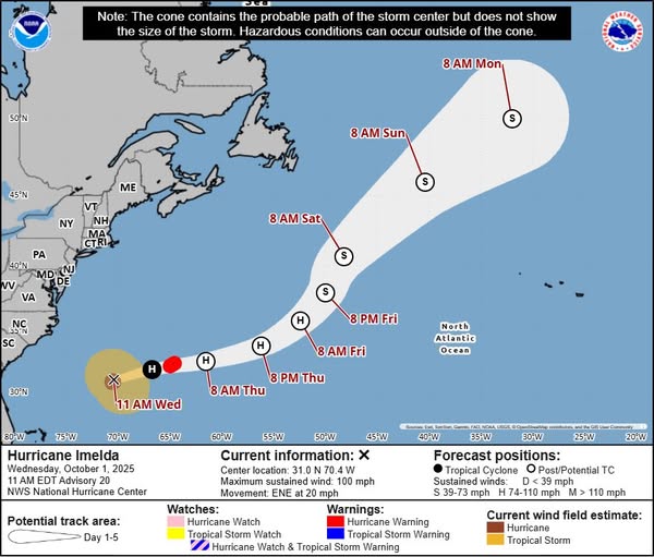
While Hurricanes Imelda and Humberto remain offshore and are accelerating eastward, northeastern North Carolina continues to feel their effects through persistent strong winds, dangerous surf, and significant coastal flooding that has closed portions of Highway 12 and suspended ferry service to Ocracoke Island.
Road Closures and Travel Impacts
NC Highway 12 status as of Wednesday Morning:
- CLOSED: North end of Ocracoke Island
- SUSPENDED: Hatteras-Ocracoke ferry service
- MAJOR OVERWASH: Secondary roads in Rodanthe
- OPEN BUT HAZARDOUS: Remainder of NC 12, with blown sand in multiple locations and standing water in Buxton and Hatteras
NC Department of Transportation crews are working Wednesday to clear roadways and fortify dunes ahead of the afternoon’s high tide, when additional ocean overwash is anticipated. So far, no roadway damage has been reported, but conditions remain dynamic.
If you must travel today, drive with EXTREME CAUTION.
Conditions and hazards
A tight pressure gradient between the offshore hurricanes and high pressure building in from the north is generating strong northeast winds across the region. Multiple coastal and marine hazards remain in effect:
Coastal Flooding
Coastal Flood Warning and Advisories are in effect for potential inundation of 1-3 feet in vulnerable areas, with the likelihood of ocean overwash along Hatteras and Ocracoke Islands. Elevated water levels continue across many Eastern North Carolina tidal waterways, with minor impacts ongoing or expected.
High tide is occurring over the next 2-4 hours (from noon), with notable ocean overwash and wave runup expected once again along the coast.
Wind
Wind Advisory is in effect for the Outer Banks and Carteret County. Strong northeast winds will persist throughout the day.
Marine Hazards
- High Rip Current Risk along all Eastern North Carolina beaches
- High Surf Advisory in effect
- Gale Warnings across most coastal waters
- Small craft should remain in port
National Seashore Information Disrupted
Due to the federal government shutdown that began October 1, Cape Hatteras National Seashore is no longer posting updates on social media. Visitors and residents who typically rely on the National Seashore’s social media channels for beach access, safety information, and condition updates will need to seek information from alternative sources during this period.

Safety Recommendations
Beach Safety:
- DO NOT enter the water – life-threatening rip currents are present
- Stay off beaches during high tide when large waves and overwash are occurring
- Observe all beach closures and warnings
Travel Safety:
- Avoid unnecessary travel on NC 12
- Never drive through standing water or areas of ocean overwash
- Turn around, don’t drown – even shallow water can sweep vehicles away
- Allow extra travel time and expect delays
Residents:
- Secure outdoor items that could be blown away or carried by floodwaters
- Move vehicles away from flood-prone areas
- Stay informed as conditions continue to evolve
When Will Conditions Improve?
As Hurricanes Imelda and Humberto accelerate eastward Wednesday (Oct. 1), conditions are expected to gradually improve. However, elevated water levels, strong winds, and dangerous marine conditions will persist through Wednesday and possibly into Thursday. Multiple rounds of coastal flooding remain possible during high tide cycles.
Stay informed
Monitor official sources for the latest information:
- National Weather Service Wakefield, VA and NWS Newport/Morehead City for forecast updates
- NC Department of Transportation for NC 12 road conditions and closures
- Local emergency management for your county
- Ferry service updates at ncdot.gov/ferry
This is an evolving situation.
Information provided by National Weather Service Newport/Morehead City, National Weather Service Wakefield VA, NC Department of Transportation, and NOAA National Hurricane Center